Hiking for The Scaredy Cat: Hikes in and around Vancouver, B.C. Canada
  • Trail Information
    • The Hiking Trails & Safety Information >
      • Abby Grind: Abbotsford
      • Alder Flats: Golden Ears
      • Alouette Mtn: Golden Ears Provincial Park
      • Ancient Cedars Trail
      • Al's Habrich Ridge Trail: Sea to Sky Gondola
      • B.C.M.C. Grouse Mountain
      • Bear Mtn: Mission, BC
      • Big Cedar & Kennedy Falls: Mount Fromme
      • Blue Mountain:Coquitlam
      • Bosumarne Falls: Chilliwack, BC
      • Bowen Lookout:Cypress Mountain
      • Bridal Falls Lookout: Chilliwack-Agassiz
      • Brother's Creek: North Vancouver
      • Community Forest: Chilliwack
      • Community Forest-Gloria Lookout-Mt. Thurston-Elk Mtn-Chilliwack
      • Coquitlam Crunch: Coquitlam
      • Cheakamus Lake: Whistler
      • Crystal Falls: Coquitlam, BC
      • Dewdney Grind: Mission
      • Diez Vistas: Buntzen Lake
      • Dragon's Back: Hope, BC
      • East-West Connector Bridge Trail~Golden Ears Provincial Park
      • Eaton Lake: Hope
      • Elfin Lakes: Squamish
      • Elk Mountain: Chilliwack
      • Evan's Creek: Golden Ears Provincial Park
      • First Peak: Seymour Mountain
      • Ford Mtn: Chilliwack
      • Grouse Grind: West Vancouver
      • Garibaldi Lake: Squamish
      • Harrison Grind/Campbell Lake: Fraser Valley
      • Harrison Lookout/Fire Tower
      • Heather Trail: Manning Park
      • High Note Trail: Whistler
      • Hillkeep: Chilliwack
      • Hope Lookout Trail
      • Horne Lake Caves Provincial Park: Vancouver Island
      • Jacobson's Lake to Palmer Pond
      • Joffre Lakes: Pemberton
      • Jug Island: Belcarra Regional Park
      • Ladner Creek Train Trestle: Coquihalla Hwy
      • Killarney Lake: Bowen Island
      • Lake Lovely-Squamish
      • Larch Meadows: Manning Park
      • Levette Lake Loop: Squamish
      • Lewx Qwo:m (luhw KWOM): Chilliwack
      • Lindeman & Greendrop Lakes: Chilliwack
      • Lightning Lakes: Manning Park
      • Lindsay Lake Loop: Buntzen Lake
      • Little Douglas Lake: Coquihalla Summit
      • Lower Falls-East Canyon Parking Lot: Golden Ears
      • Lynn Loop: Lynn Headwaters Regiona Park
      • Lower Hollyburn: Cypress Mtn
      • Lynn Peak: Lynn Headwaters Regional Park
      • McKee Peak-Cliffside Caves
      • Mehatl Falls
      • Menzies: Golden Ears Provincial Park
      • Minnekhada Park: Coquitlam
      • Mount Cheam: Chilliwack
      • Mount Fromme: North Van
      • Mount Sleese to Memorial Plaque: Chiliwack
      • Mount St. Benedict: Mission
      • Mount Strachan: Mount Seymour
      • Mt. Thom: Chilliwack
      • Mt. Gardner: Bowen Island
      • Mt. Woodslide
      • Munro & Denette Lakes: Coquitlam
      • Mystery Lake: Mount Seymour
      • Needle Peak/Flatiron: Coquihalla Highway
      • Norvan Falls: Lynn Headwaters Regional Park
      • Othello Tunnels-Nicola Valley Loop
      • Parkhurst Ghost Town: Whistler
      • Panorama Ridge: Squamish
      • Petgill Lake: Howe Sound
      • Poland Lake-EC Manning Park
      • Quarry Rock: Deep Cove
      • Ravens Bluff-Mission
      • Red Mountain: Mission
      • Salmon Ridge Trail: Chilliwack, BC
      • Sandy Cove Trail: Harrison Hot Springs
      • Sasquatch Caves: Hope
      • Sea to Summit: Sea to Sky Gondola
      • Skyline: Grouse Mountain
      • Skyline 1: Manning Park
      • Spirit Caves-Yale, BC
      • St. Mark's: Cypress Mountain
      • Statlu Lake
      • The Stawamus Chief: Squamish
      • Tikwalus Trail: Spuzzum
      • Trickle Creek Treehouse
      • Thacker Mountain Trail: Hope
      • Tunnel Bluffs: Howe Sound
      • Vedder: Chilliwack
      • Watersprite Lake: Squamish
      • Wedgemont Lake: Whislter
      • Wells Peak
      • Widgeon Falls
      • Williams Peak
      • Windy Joe: Manning Park
      • Woodland Walk to Sawblade Falls
      • Zoa Peak: Coquihallia Hwy
    • The Snowshoe Trails & Safety Info >
      • Artist Point
      • Bowen Lookout
      • Dog Mountain: Day
      • Callaghan Valley
      • Dog Mountain: Night
      • Eagle Bluffs
      • Elfin Lakes to Red Heather Hut >
        • Fat Dog
        • First Pump
        • Hollyburn
        • Lightning Lakes Loop
        • Rainbow Lake
        • Sasquatch Mountain Snowshoe: Hemlock Valley
        • SS Grind
        • Stawberry Flats
        • Zoa
    • The U.S.A. Hikes >
      • Blue Lake: Northern Cascades
      • Chain Lakes
      • Damfino Lakes
      • Deception Pass State Park: Washington, USA
      • Oyster Dome
      • Yellow Aster Butte
    • The Trail Walks >
      • Aldergrove Regional Park: Aldergrove
      • Blue Heron Reserve: Chilliwack
      • Brae Island: Fort Langley
      • Burn's Bog: Delta
      • Burnaby Lake Loop: Burnaby
      • Campbell Valley: Langley
      • Cathederal Grove: MacMillian Provincial Park:
      • Delta Watershed
      • East Sector Lands: Harrison Hot Springs
      • Elgin Park: Surrey, BC
      • Green Timbers: Surrey
      • High Knoll Park: Surrey
      • Houston Trail: Fort Langley
      • Katzie Marsh Loop: Pitt Meadows
      • Lower Falls: Golden Ears: Maple Ridge
      • Lower Seymour Conservation: North Vancouver
      • Lighthouse Park: West Vancouver
      • Mud Bay: Surrey
      • Redwood Park: Surrey
      • Reifel Bird Santuary: Delta
      • Rice Lake: North Vancouver
      • Richmond Nature Park: Richmond
      • Rolley Lake: Mission
      • Ruth Johnson Park: White Rock
      • Sasamat Lake: Port Moody
      • Spirea Trail: Golden Ears
      • Sunnyside Urban Forest: Surrey
      • Serpentine Bird Santuary
      • Shoesmith East Trail Loop: Maple Ridge
      • Spirit Trail: Ladner
      • Stanley Park Seawall: Vancouver
      • Sye'xw Cho'teqw Adventure Park
      • The Jetti: Iona Beach, Richmond
      • Tynehead
      • Yew Lake
  • My Blogging
  • Jorullo Bridge Hiking Tour Puerto Vallarta, Mexico
  • Mt. Kilimanjaro
  • In the River Valley Hikes
  • West Coast Trail
  • Peru
  • Hiking Snapshots
    • Thru Hikes
    • Bears & Cougars +
    • Proper Hiking Footwear
    • Trail Etiquette
  • Blog

My  BlogGing

Picture

Five Spectacular Weekend Hikes by Lori Pederson

8/9/2014

0 Comments

 
Picture
Picture
Picture
Picture
Picture

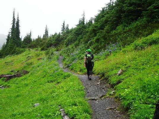
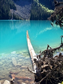
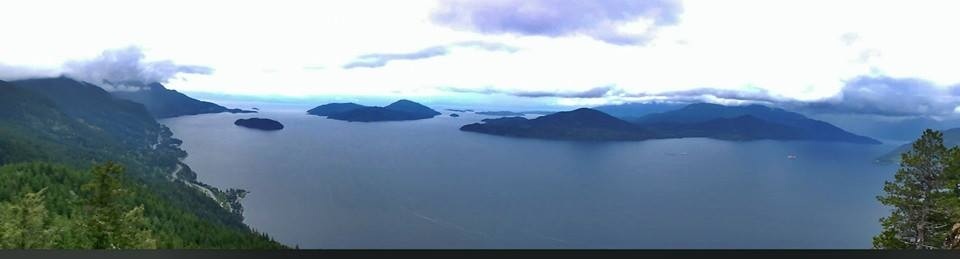
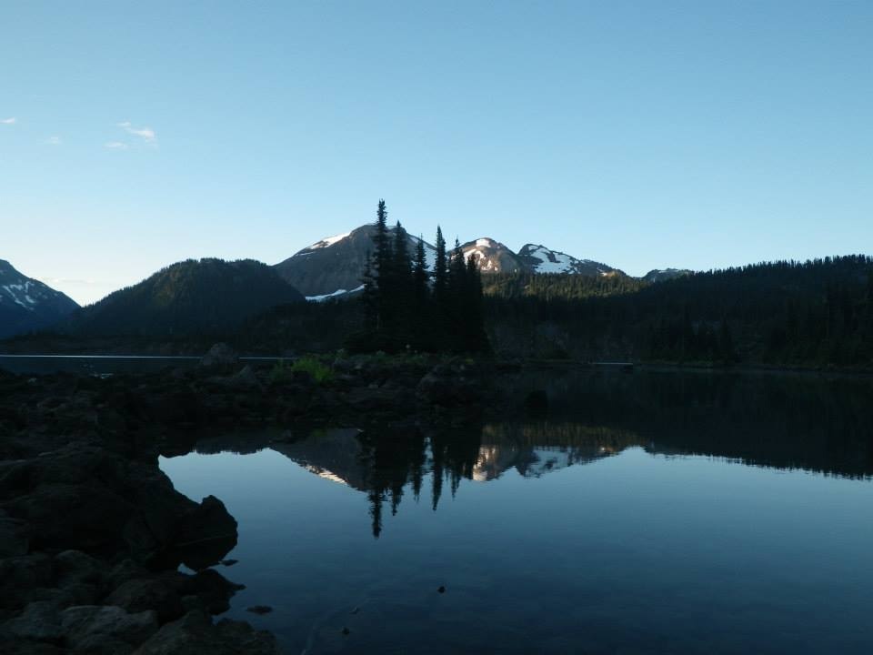
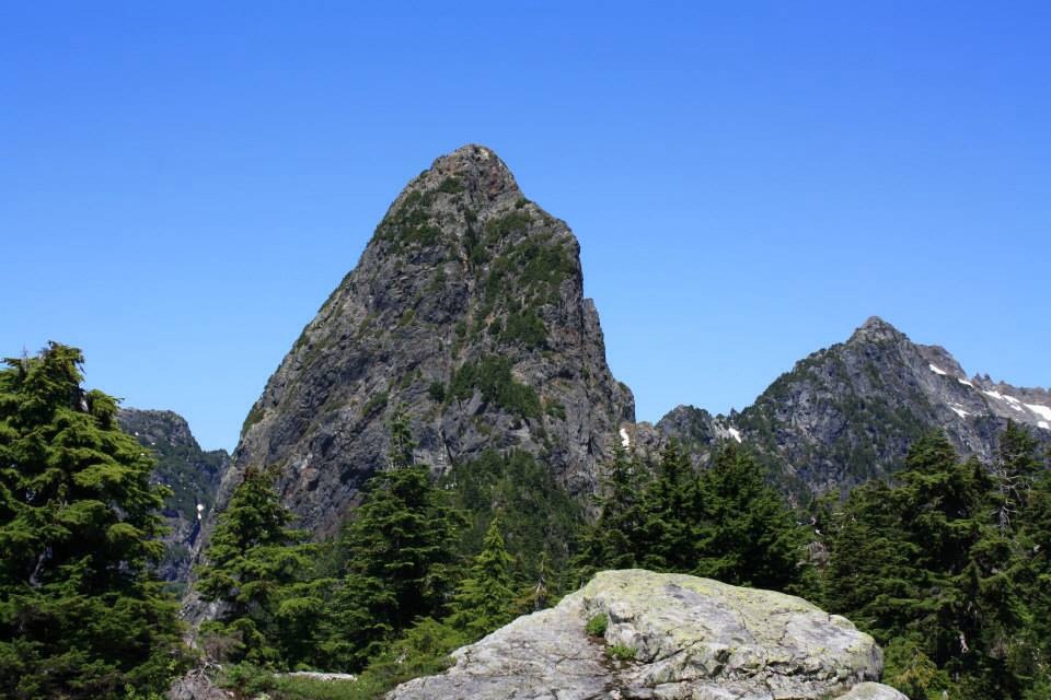
One-Garibaldi Lake in  Squamish
Picture credit: Lori Pederson

It's my favorite hike at 18 Km's return with 900 meters of elevation. The first 6.5 Km's are wide switchbacks on a groomed trail. Once at the junction the Whiskey Jacks swoop down to feet you. If you go left, which I suggest, it's another 5 Km's with about 100 m more elevation. This way you'll go all the way to The Black Tusk junction. With streams, sweet smelling meadows with wild flowers everywhere. Once at this junction go right to Garibaldi Lake. As you walk there's some un named alpine lakes or tarn and views of distant peaks. Soon the blue green waters of the lake pop through the trees. The water colour us so amazing you just can't believe your eyes. Now you travel down the switchbacks to the lake and crop oasis over a bridge with a railing. Go around the lake to the campsites. Keep walking to the ranger stations. The views get more stunning. After your done go back the way you came and once at the bottom of the switchbacks go left. As you carry on you'll come to Lesser & Barrier Lakes and Barrier Lookout. Spectacular views! You are now back at the junction you were earlier. It's down the switchbacks and back to your car. This is my all time favorite hike!

Two-Heather Trail in Manning Park
Picture credit: Lori Pederson

Drive to Manning a Park Lodge and up to the upper parking lot. Start your hike at the Nature Loop Trail which joins the Heather Trail. This trail us only 400 meters of elevation and can be 22 Km's and longer or shorter. You decide! I would suggest to at least go to the meadows and if your feet can take you as far as The three Brothers, that's a perfect day. The trail is rooty & rocky and has some descend in the beginning and elevation and more elevation at the end. The trail snakes it's way to the meadows. Once in the meadows, it's a walk in the park, but what a park. Wild flowers and mountains everywhere. It's so pretty. If you decide to summit The Three Brother's it's quite a climb with some exposed scrambling, more elevation and Km's Up to you...or you can keep walking with more meadows as you pass just under the brothers. Once happy turn around on this in/out trail.

Three-Joffre Lakes in Pemberton
Picture credit: Lori Pederson

Ihad stayed away from Joffre Lakes for a few years because of the technical boulder field you had to climb across. I slipped every time and with scratches I thought I would never return until I read the boulder field was gone. I had to check it out for myself. Joffre Lakes is the very first hike to go from My Scaredy Cat Hikes to My Hikes.
Five minutes into the hike you are treated to Lower Lake, the first of three. It's green and blue colour with the glacier back drop is exciting to see. The bugs are fierce here so spray on. After you have taken many pictures head back to the trail branch and start your trek to Middle Lake. It is a groomed path that climbs slightly. I'm not sure how BC Parks got rid of the boulder field but I am grateful. Soon you come into the forest and a trail emerges.
To the right it looks like BC Parks is making a new trail to Middle Lake. At present take the left more rugged old trail up to Middle Lake. There are some steep sections but lots of roots, logs and rocks to help you up and over these sections. Soon a beautiful Middle Lake appears and is spectacular. Your real destination is just 1.5 Km's away and you've completed the hard work. You'll walk around the lake a little and a new BC Parks trail has been upgraded to Upper Lake. Take this trail. It has some stairs, ladders, bridges and a beautiful cascading waterfall. Just before Upper Lake appears there's a carved bear you are suppose to acknowledge to receive good hiking weather. It's an easy path and soon you will come to some bigger rocks. Carefully walk or crawl to your left for a nice view point or lunch spot or go right and walk around the left to the campsite. There is a pit toilet here, several campsites and the Matier Glacier. You can climb up it carefully along the loose rocks. If you get high enough you can get a picture of all three lakes. Once your all rested up head back the way you came. The descent from Middle Lake to Lower Lake is steep in some areas so take your time and if you brought poles they will be helpful. 

Four-Tunnel Bluffs Hike in Lions Bay
Picture Credit:Dave Lastik

Pass Lions Bay.. You'll cross a small bridge 'M Creek Bridge' just a little bit after on your left is a pull out, park there. There are 24 spots. You won't be able to turn in and will have to drive further up the highway to safely turn around. Your hike starts at the north end of the parking lot across the street. Careful as you cross as the traffic on The Sea to Sky can be busy. You see a 'Rockfall Hazard' sign. The trail is just before that with a little yellow sign. It's 12 Km's return and 691 m elevation gain. For the record there are no tunnels but several view outcrop bluffs. Even if you make it to the fifth viewpoint you will see a stunning view.
Tunnel Bluffs is a very well marked trail. I only wish it had the Km's & elevation marked on each of the trail markers, so you knew how much further you had to go. You will start climbing right away. As you climb keep a lookout for several rocky bluff view points. Some nicer than others. They all have little 'view' signs. You cross a few logs cut out like stairs and will keep going steeply up for an hour. There's a couple rope assists to help you up or down. When you come to the second rope assist it levels off. It's a beautiful walk on an old logging road that's really a path and old growth forest. Some of the trees are what you would see before logging began. There are some beautiful Arbutus trees and some that were so wide I couldn't wrap my arms around them. It is here where you will cross a couple of creeks, one named 'Yahoo Creek.' It's very peaceful. Finally you will come to a sign indicating you've done 5 Km's with 1 to go to the final viewpoint. It's still level for a bit then some loose rocks/scree for a short time. There are two viewpoints at the top. One is amazing while the other is covered in the trees. When your done head back the way you came... It's a steep, slippery trek down...Be careful! I wore my Microspikes and it helped. I would suggest poles for your decent. If you want you can carry on another 6 Km's to Hat Mountain, where there is a nice little cabin. I myself have not done that so I can't say what the trail conditions are. 

Five-Alouette Mountain in Golden Ears 
Picture credit: Lori Pederson


Alouette Mountain is a beautiful long 22 km hike through an old growth forest. The trail is maintained by a hiking club and is in need of repair and some chain assists at the end would be helpful. There is some blowdown on the trails but most has been cleared since my last year visit. Volunteering to help clean up the trails would be a rewarding time and a way to pay-it-forward. Ridge Meadows is always looking for volunterrs, if you are interested in trail matain in this park or our local parks read my recent blog via Vancouver Trails on how to get involved:
The hike itself is fairly easy to find your way. The trails are well marked with Alouette Mountain signs. You will park by The Incline Trail (there is more parking at Mike Lake...there is also a pit toilet here.) If you park near the limited parking, the trail head starts here to your right. Follow the steep trail up, up, up until you reach a road and go right and after a switchback go left. Take the signpost trail to the right uphill through second growth forest. You will come to a road and turn right, stay on the road for a brief time and then to the right. Soon you will enter an old growth forest and you will come to a road and turn right. There is a beautiful viewpoint with a picnic table. Go up the road and past a helicopter landing pad and go left on a trail (it has a big arrow made of rocks). When we went through here there was a lot of blow down in 2013 but in 2014 it wasn't nearly as bad. In 2013 we were up and under tree after tree. At one point we stepped off the trail slightly to get around a big tree and stepped on a underground hornets nest. We were stung many times...Be careful as we did not see the nest or the hornets. They slipped in our hiking socks, under our clothes and bite through our pants. This has never happened to me in all my hikes. We were told to go Lake Beautiful way to Alouette Mtn but we were not sure how so we carried on through the blowdown. I would guess about 40 trees. The trail gets steeper and steeper but nothing un-comfortable. You will pass a couple of meadows & lakes and your last grunt and you are at two big rocks that you must climb. It is not scary. You can go up the side with some small trees to assist or if you have good balance there are some grips to walk on perhaps a little scrambling. I would love to see some chains here to assist you up...Finally you are at the top of a rocky outcrop. There are many different views and I hope you did not choose a cloudy day so you can soak in the beauty. 

0 Comments


Leave a Reply.

    Author.

    I work for Surrey School District as an Education Assistant. In my free time I enjoy hiking, snowshoeing, going off-road, dragon boating, writing & hanging with my huskies.

    Archives

    March 2021
    November 2020
    October 2019
    September 2019
    March 2019
    September 2018
    December 2017
    October 2017
    September 2015
    August 2015
    June 2015
    April 2015
    March 2015
    February 2015
    January 2015
    December 2014
    November 2014
    October 2014
    August 2014
    July 2014
    June 2014
    May 2014
    April 2014
    March 2014
    October 2013
    September 2013
    July 2013
    June 2013

    Categories

    All

    RSS Feed

Proudly powered by Weebly
Photos used under Creative Commons from breyeschow, A Chilling Soul, iwona_kellie, CarbonNYC, simonov
  • Trail Information
    • The Hiking Trails & Safety Information >
      • Abby Grind: Abbotsford
      • Alder Flats: Golden Ears
      • Alouette Mtn: Golden Ears Provincial Park
      • Ancient Cedars Trail
      • Al's Habrich Ridge Trail: Sea to Sky Gondola
      • B.C.M.C. Grouse Mountain
      • Bear Mtn: Mission, BC
      • Big Cedar & Kennedy Falls: Mount Fromme
      • Blue Mountain:Coquitlam
      • Bosumarne Falls: Chilliwack, BC
      • Bowen Lookout:Cypress Mountain
      • Bridal Falls Lookout: Chilliwack-Agassiz
      • Brother's Creek: North Vancouver
      • Community Forest: Chilliwack
      • Community Forest-Gloria Lookout-Mt. Thurston-Elk Mtn-Chilliwack
      • Coquitlam Crunch: Coquitlam
      • Cheakamus Lake: Whistler
      • Crystal Falls: Coquitlam, BC
      • Dewdney Grind: Mission
      • Diez Vistas: Buntzen Lake
      • Dragon's Back: Hope, BC
      • East-West Connector Bridge Trail~Golden Ears Provincial Park
      • Eaton Lake: Hope
      • Elfin Lakes: Squamish
      • Elk Mountain: Chilliwack
      • Evan's Creek: Golden Ears Provincial Park
      • First Peak: Seymour Mountain
      • Ford Mtn: Chilliwack
      • Grouse Grind: West Vancouver
      • Garibaldi Lake: Squamish
      • Harrison Grind/Campbell Lake: Fraser Valley
      • Harrison Lookout/Fire Tower
      • Heather Trail: Manning Park
      • High Note Trail: Whistler
      • Hillkeep: Chilliwack
      • Hope Lookout Trail
      • Horne Lake Caves Provincial Park: Vancouver Island
      • Jacobson's Lake to Palmer Pond
      • Joffre Lakes: Pemberton
      • Jug Island: Belcarra Regional Park
      • Ladner Creek Train Trestle: Coquihalla Hwy
      • Killarney Lake: Bowen Island
      • Lake Lovely-Squamish
      • Larch Meadows: Manning Park
      • Levette Lake Loop: Squamish
      • Lewx Qwo:m (luhw KWOM): Chilliwack
      • Lindeman & Greendrop Lakes: Chilliwack
      • Lightning Lakes: Manning Park
      • Lindsay Lake Loop: Buntzen Lake
      • Little Douglas Lake: Coquihalla Summit
      • Lower Falls-East Canyon Parking Lot: Golden Ears
      • Lynn Loop: Lynn Headwaters Regiona Park
      • Lower Hollyburn: Cypress Mtn
      • Lynn Peak: Lynn Headwaters Regional Park
      • McKee Peak-Cliffside Caves
      • Mehatl Falls
      • Menzies: Golden Ears Provincial Park
      • Minnekhada Park: Coquitlam
      • Mount Cheam: Chilliwack
      • Mount Fromme: North Van
      • Mount Sleese to Memorial Plaque: Chiliwack
      • Mount St. Benedict: Mission
      • Mount Strachan: Mount Seymour
      • Mt. Thom: Chilliwack
      • Mt. Gardner: Bowen Island
      • Mt. Woodslide
      • Munro & Denette Lakes: Coquitlam
      • Mystery Lake: Mount Seymour
      • Needle Peak/Flatiron: Coquihalla Highway
      • Norvan Falls: Lynn Headwaters Regional Park
      • Othello Tunnels-Nicola Valley Loop
      • Parkhurst Ghost Town: Whistler
      • Panorama Ridge: Squamish
      • Petgill Lake: Howe Sound
      • Poland Lake-EC Manning Park
      • Quarry Rock: Deep Cove
      • Ravens Bluff-Mission
      • Red Mountain: Mission
      • Salmon Ridge Trail: Chilliwack, BC
      • Sandy Cove Trail: Harrison Hot Springs
      • Sasquatch Caves: Hope
      • Sea to Summit: Sea to Sky Gondola
      • Skyline: Grouse Mountain
      • Skyline 1: Manning Park
      • Spirit Caves-Yale, BC
      • St. Mark's: Cypress Mountain
      • Statlu Lake
      • The Stawamus Chief: Squamish
      • Tikwalus Trail: Spuzzum
      • Trickle Creek Treehouse
      • Thacker Mountain Trail: Hope
      • Tunnel Bluffs: Howe Sound
      • Vedder: Chilliwack
      • Watersprite Lake: Squamish
      • Wedgemont Lake: Whislter
      • Wells Peak
      • Widgeon Falls
      • Williams Peak
      • Windy Joe: Manning Park
      • Woodland Walk to Sawblade Falls
      • Zoa Peak: Coquihallia Hwy
    • The Snowshoe Trails & Safety Info >
      • Artist Point
      • Bowen Lookout
      • Dog Mountain: Day
      • Callaghan Valley
      • Dog Mountain: Night
      • Eagle Bluffs
      • Elfin Lakes to Red Heather Hut >
        • Fat Dog
        • First Pump
        • Hollyburn
        • Lightning Lakes Loop
        • Rainbow Lake
        • Sasquatch Mountain Snowshoe: Hemlock Valley
        • SS Grind
        • Stawberry Flats
        • Zoa
    • The U.S.A. Hikes >
      • Blue Lake: Northern Cascades
      • Chain Lakes
      • Damfino Lakes
      • Deception Pass State Park: Washington, USA
      • Oyster Dome
      • Yellow Aster Butte
    • The Trail Walks >
      • Aldergrove Regional Park: Aldergrove
      • Blue Heron Reserve: Chilliwack
      • Brae Island: Fort Langley
      • Burn's Bog: Delta
      • Burnaby Lake Loop: Burnaby
      • Campbell Valley: Langley
      • Cathederal Grove: MacMillian Provincial Park:
      • Delta Watershed
      • East Sector Lands: Harrison Hot Springs
      • Elgin Park: Surrey, BC
      • Green Timbers: Surrey
      • High Knoll Park: Surrey
      • Houston Trail: Fort Langley
      • Katzie Marsh Loop: Pitt Meadows
      • Lower Falls: Golden Ears: Maple Ridge
      • Lower Seymour Conservation: North Vancouver
      • Lighthouse Park: West Vancouver
      • Mud Bay: Surrey
      • Redwood Park: Surrey
      • Reifel Bird Santuary: Delta
      • Rice Lake: North Vancouver
      • Richmond Nature Park: Richmond
      • Rolley Lake: Mission
      • Ruth Johnson Park: White Rock
      • Sasamat Lake: Port Moody
      • Spirea Trail: Golden Ears
      • Sunnyside Urban Forest: Surrey
      • Serpentine Bird Santuary
      • Shoesmith East Trail Loop: Maple Ridge
      • Spirit Trail: Ladner
      • Stanley Park Seawall: Vancouver
      • Sye'xw Cho'teqw Adventure Park
      • The Jetti: Iona Beach, Richmond
      • Tynehead
      • Yew Lake
  • My Blogging
  • Jorullo Bridge Hiking Tour Puerto Vallarta, Mexico
  • Mt. Kilimanjaro
  • In the River Valley Hikes
  • West Coast Trail
  • Peru
  • Hiking Snapshots
    • Thru Hikes
    • Bears & Cougars +
    • Proper Hiking Footwear
    • Trail Etiquette
  • Blog