Hiking for The Scaredy Cat: Hikes in and around Vancouver, B.C. Canada
  • Trail Information
    • The Hiking Trails & Safety Information >
      • Abby Grind: Abbotsford
      • Alder Flats: Golden Ears
      • Alouette Mtn: Golden Ears Provincial Park
      • Ancient Cedars Trail
      • Al's Habrich Ridge Trail: Sea to Sky Gondola
      • B.C.M.C. Grouse Mountain
      • Bear Mtn: Mission, BC
      • Big Cedar & Kennedy Falls: Mount Fromme
      • Blue Mountain:Coquitlam
      • Bosumarne Falls: Chilliwack, BC
      • Bowen Lookout:Cypress Mountain
      • Bridal Falls Lookout: Chilliwack-Agassiz
      • Brother's Creek: North Vancouver
      • Community Forest: Chilliwack
      • Community Forest-Gloria Lookout-Mt. Thurston-Elk Mtn-Chilliwack
      • Coquitlam Crunch: Coquitlam
      • Cheakamus Lake: Whistler
      • Crystal Falls: Coquitlam, BC
      • Dewdney Grind: Mission
      • Diez Vistas: Buntzen Lake
      • Dragon's Back: Hope, BC
      • East-West Connector Bridge Trail~Golden Ears Provincial Park
      • Eaton Lake: Hope
      • Elfin Lakes: Squamish
      • Elk Mountain: Chilliwack
      • Evan's Creek: Golden Ears Provincial Park
      • First Peak: Seymour Mountain
      • Ford Mtn: Chilliwack
      • Grouse Grind: West Vancouver
      • Garibaldi Lake: Squamish
      • Harrison Grind/Campbell Lake: Fraser Valley
      • Harrison Lookout/Fire Tower
      • Heather Trail: Manning Park
      • High Note Trail: Whistler
      • Hillkeep: Chilliwack
      • Hope Lookout Trail
      • Horne Lake Caves Provincial Park: Vancouver Island
      • Jacobson's Lake to Palmer Pond
      • Joffre Lakes: Pemberton
      • Jug Island: Belcarra Regional Park
      • Ladner Creek Train Trestle: Coquihalla Hwy
      • Killarney Lake: Bowen Island
      • Lake Lovely-Squamish
      • Larch Meadows: Manning Park
      • Levette Lake Loop: Squamish
      • Lewx Qwo:m (luhw KWOM): Chilliwack
      • Lindeman & Greendrop Lakes: Chilliwack
      • Lightning Lakes: Manning Park
      • Lindsay Lake Loop: Buntzen Lake
      • Little Douglas Lake: Coquihalla Summit
      • Lower Falls-East Canyon Parking Lot: Golden Ears
      • Lynn Loop: Lynn Headwaters Regiona Park
      • Lower Hollyburn: Cypress Mtn
      • Lynn Peak: Lynn Headwaters Regional Park
      • McKee Peak-Cliffside Caves
      • Mehatl Falls
      • Menzies: Golden Ears Provincial Park
      • Minnekhada Park: Coquitlam
      • Mount Cheam: Chilliwack
      • Mount Fromme: North Van
      • Mount Sleese to Memorial Plaque: Chiliwack
      • Mount St. Benedict: Mission
      • Mount Strachan: Mount Seymour
      • Mt. Thom: Chilliwack
      • Mt. Gardner: Bowen Island
      • Mt. Woodslide
      • Munro & Denette Lakes: Coquitlam
      • Mystery Lake: Mount Seymour
      • Needle Peak/Flatiron: Coquihalla Highway
      • Norvan Falls: Lynn Headwaters Regional Park
      • Othello Tunnels-Nicola Valley Loop
      • Parkhurst Ghost Town: Whistler
      • Panorama Ridge: Squamish
      • Petgill Lake: Howe Sound
      • Poland Lake-EC Manning Park
      • Quarry Rock: Deep Cove
      • Ravens Bluff-Mission
      • Red Mountain: Mission
      • Salmon Ridge Trail: Chilliwack, BC
      • Sandy Cove Trail: Harrison Hot Springs
      • Sasquatch Caves: Hope
      • Sea to Summit: Sea to Sky Gondola
      • Skyline: Grouse Mountain
      • Skyline 1: Manning Park
      • Spirit Caves-Yale, BC
      • St. Mark's: Cypress Mountain
      • Statlu Lake
      • The Stawamus Chief: Squamish
      • Tikwalus Trail: Spuzzum
      • Trickle Creek Treehouse
      • Thacker Mountain Trail: Hope
      • Tunnel Bluffs: Howe Sound
      • Vedder: Chilliwack
      • Watersprite Lake: Squamish
      • Wedgemont Lake: Whislter
      • Wells Peak
      • Widgeon Falls
      • Williams Peak
      • Windy Joe: Manning Park
      • Woodland Walk to Sawblade Falls
      • Zoa Peak: Coquihallia Hwy
    • The Snowshoe Trails & Safety Info >
      • Artist Point
      • Bowen Lookout
      • Dog Mountain: Day
      • Callaghan Valley
      • Dog Mountain: Night
      • Eagle Bluffs
      • Elfin Lakes to Red Heather Hut >
        • Fat Dog
        • First Pump
        • Hollyburn
        • Lightning Lakes Loop
        • Rainbow Lake
        • Sasquatch Mountain Snowshoe: Hemlock Valley
        • SS Grind
        • Stawberry Flats
        • Zoa
    • The U.S.A. Hikes >
      • Blue Lake: Northern Cascades
      • Chain Lakes
      • Damfino Lakes
      • Deception Pass State Park: Washington, USA
      • Oyster Dome
      • Yellow Aster Butte
    • The Trail Walks >
      • Aldergrove Regional Park: Aldergrove
      • Blue Heron Reserve: Chilliwack
      • Brae Island: Fort Langley
      • Burn's Bog: Delta
      • Burnaby Lake Loop: Burnaby
      • Campbell Valley: Langley
      • Cathederal Grove: MacMillian Provincial Park:
      • Delta Watershed
      • East Sector Lands: Harrison Hot Springs
      • Elgin Park: Surrey, BC
      • Green Timbers: Surrey
      • High Knoll Park: Surrey
      • Houston Trail: Fort Langley
      • Katzie Marsh Loop: Pitt Meadows
      • Lower Falls: Golden Ears: Maple Ridge
      • Lower Seymour Conservation: North Vancouver
      • Lighthouse Park: West Vancouver
      • Mud Bay: Surrey
      • Redwood Park: Surrey
      • Reifel Bird Santuary: Delta
      • Rice Lake: North Vancouver
      • Richmond Nature Park: Richmond
      • Rolley Lake: Mission
      • Ruth Johnson Park: White Rock
      • Sasamat Lake: Port Moody
      • Spirea Trail: Golden Ears
      • Sunnyside Urban Forest: Surrey
      • Serpentine Bird Santuary
      • Shoesmith East Trail Loop: Maple Ridge
      • Spirit Trail: Ladner
      • Stanley Park Seawall: Vancouver
      • Sye'xw Cho'teqw Adventure Park
      • The Jetti: Iona Beach, Richmond
      • Tynehead
      • Yew Lake
  • My Blogging
  • Jorullo Bridge Hiking Tour Puerto Vallarta, Mexico
  • Mt. Kilimanjaro
  • In the River Valley Hikes
  • West Coast Trail
  • Peru
  • Hiking Snapshots
    • Thru Hikes
    • Bears & Cougars +
    • Proper Hiking Footwear
    • Trail Etiquette
  • Blog

My  BlogGing

Picture

Scaredy Cat's Top Ten Day Hikes: 

3/22/2014

1 Comment


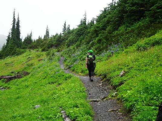
It's hard to pick my favorite hikes as there are many. This summer I plan to do some new & challenging ones. I'm steppin' out if my comfort zone to grow and inspire you to join me. These are my favorite hikes with stunning views. If you love being in nature and a reward at the end of your climb, then check out these.

1) Munro & Dennett Lakes, Port Coquitlam, BC 

You will find the trailhead to Munro Lake just past the gate to Minnekhada  Regional Park on Quarry Road. On the road you will see 2.5 Km's sign and then a small parking area for two cars on the right side. The trail is to the left up an old logging road. At the top of the road you will see a white sign that says Munro Lake to the right. The hike itself is an in-out trail at 10 Km's return and there are no pitt toilets or washrooms. The trail has trail markers but can be confusing at times. The trail climbs steeply almost the whole way. It is mostly surrounded by bushes and is quite skinny at times. There's a couple of blowdown trees but foot areas have been kindly cut out for you to put your foot in as you step over. As you get higher you will see many trails within the trail, it's a bit confusing...but they all seem to link up to the main trail. There are two lookouts and it's best to hike this on a sunny day so you don't miss out on the rewarding views. You will come to a branch in the trail at 700 meters. Make sure you go to the left to see the south view point that sits on a rocky outcrop then continue on to the lakes. You will reach Munro Lake first and then climb another 130 meters to reach Dennett Lake. If you just hike to the south lookout you will have an amazing day. This day at the end of November we did just that as it was pouring rain and very slippery coming down. It is a hike I plan to do again. Best done on a dry, frost & snow free day. Scaredy Cat says you won't loose any of your nine lives. Happy & safe trails! 

2) Diez Vistas, Port Moody, BC

You can do this as an in-out hike or a loop. I will describe it as a loop. It is a steep hike and as you near the top there are some rope assists but after that it's pretty flat. There are some sections where you will need to be careful as it does drop off...most of these are at view points. After you pass the 10th view or Diez Vista you will start to make your decent. It is steep coming down and can be icey or slippery on cold or rainy days. We went slow. Once you get to the bottom you will have to loop around the lake and back to the floating bridge where you started. It is a long loop...15 Km's when you are done and my feet screamed at me for a couple of days after. If you are afraid of heights then this is probably not the hike for you. It is a long hike. Scaredy Cat says...you could one of your nine lives so be careful. Best done on a dry, frost & snow free day. Happy Trails! For more information: http://www.vancouvertrails.com/trails/sendero-diez-vistas/

3) Howe Sound Crest Trail~St. Mark's Summit
Cypress Mountain, West Vancouver, BC

Head up to the top of Cypress bowl parking lot. If you need to use the washroom you should go now as there are no pitt toilets at the top. There is a restaurant here called, The Raven, it's open in the summer. Go past the building and go right past the sign (there are park maps here) and take a left to Bowen Lookout. There are signs and it is well marked. We hiked this as a sunrise hike. It's just 1.8 km to Bowen Lookout and is the perfect hike to do it with flashlights. We were well equipped with head lamps, flashlights and hiking poles. we talked loudly to let wildlife know we were on the mountain.and left a note in our car that we were there with the time, date, expected return and trail we planned to tackle, as extra insurance. Follow the BC Parks signs to Bowen Lookout. It winds through a flat WC assessable trail to a road. If you are bringing your dog you will have to go from the parking lot to the road as Dog's are not allowed on this part of trail but can go to the lookout and beyond. After you walk down the road you will start a few switchbacks. A couple are a little steep...great leg & behind workout! When you get to the top go to the left, to a beautiful lookout. That's Bowen lookout. When you are satisfied with all your pictures, head back out, go left, and continue up the hill. The trail is well groomed for a bit. You can go as far as The Lions and Deeks Lake but today I will take you to St. Mark's Summit. Keep in mind there are no signs telling you are on your way to St. Mark's, the signs will say Deeks Lake and The Lions. As you are walking keep your eyes open for a sneak peak of The Lions on your right. Soon you will come to a rooty & rocky section of trail. It starts to get a little confusing here as the trail zig zags through the forest. Follow the trail markers. You will see them and then you won't only to realize the trail marker is behind you. It is well marked if you watch and take your time. If you don't see the trail marker you have missed a step. Keep going as the trail is flat for a bit but don't get too comfortable. Soon it will climb up a steep area that is again rooty & rocky. Then it is flat again, you will go over a rocky knoll (I went up the right side and it was easy) and your last little rocky area. There is a sign that says St. Mark's Summit, go left up the rock and there is a rock to sit on and some trees to keep you safe, don't go too close to the edge as it is a steep drop~off. The view is similar to Bowen but higher...worth the extra few Km's to see it. You can carry on from here to other desired areas or retrace your steps back to Cypress Bowl parking lot. The hike itself is 11 km and 1370 m elevation gain. Best done on a dry, frost & snow free day. Scaredy Cat says be safe at the summit or you could loose one of your nine lives. Happy & safe trails!

4) High Note Trail~Whistler Mountain,
Whistler, BC
(No dogs allowed)

I would have to say that this hike is on my favorites list. There is a summer season pass you can buy, as a BC resident you get a special discount and if you go hiking twice it is worth every penny. Check and see if children are allowed on the chairlift & trails. I myself, would say this is not a safe trail for a child. There are also other benefits such as 25% off for up to 4 of your guests. Make sure you bring proof of your BC residency. You must buy your season pass on-line as at the ticket booth you will only be able to get a day's pass. Check to see if there is a BBQ (Friday, Saturday & Sunday) at the top (no one told us and we missed out a $17.00 yummy dinner...which would have been a nice treat at the top with stunning views.) After you buy your ticket (check times as the Gondola does not start early in the morning) you will need to line up but the line does move fast. After you ride the gondola up, you will need to walk to the chairlift. It is very well explained. After the chairlift ride up (it's pretty easy to step off the chairlift at the top, if you are like me and feel anxious about that). When you get to the very top there are pit toilets and nothing else until the end of your hike. The hike itself is very well marked. It is a 9.4 km trek with lots of twists and turns. Although you can hike it reverse there are some steep sections and I think going this way is a lot better. There are lots of ups and downs with a few chain assists but not scary at all. As you make your way around the mountain you will see amazing vies of The Black Tusk and Cheakamus Lake. It is stunning. There is one section that I did not like but I made it through. You will come to a big rock on your left side and a tree on your right side...it is steep here. There is a rope around the rock to hold onto. You will need to put your foot on a rock and step onto a metal grate decline. There is a gap from the the rock to the grate, It's a bit tricky if you are not flexible or too short but totally doable. There are some steep sections to come. I wouldn't want to do this hike when it had been raining but I'm sure it wouldn't bother most. You will come to two little lakes. We soaked our aching feet in one. It would be a nice place for lunch. Keep going on.This side of the trail is not as stunning. You can go up to Singing Pass (we did not do that so I can't say what it is like). Keep going and soon you will come to the last big grunt up and you make your way to the gondola area. You can have a beverage or something to eat. You only have to take the gondola down and you will be back in Whistler Village. Scaredy Cat says, you can loose one of your nine lives. Make sure you wear proper foot wear and I found a hiking pole that retracts small enough to fit in your back pack was handy! Best done on a dry, frost & snow free day. For additional information: http://www.vancouvertrails.com/trails/high-note-trail/ There are also free hiking maps in the village, which were great to have.Happy & safe trails!

5) Elk Mountain~Chilliwack, BC

Coming in at just 7 km with an 800 meter elevation gain; Elk Mountain is a beautiful hike but don't fool yourself into thinking it is an easy one. It is a butt-kicking-knee-thrashing workout! I did this hike with two elderly women 65 & 67 years old...however, I wouldn't really say they are elderly as they kicked this trails, butt.
You will start your hike after driving up a road for 8 km and then a dirt road for another 2 km. Parking is just to the left side. Don't use the pit toilet in the parking lot. If you walk up the trail a short distance there is a much cleaner one to your right, just off the trail. The one in the parking lot is very dirty. Make sure you bring lots of water...
The start of your hike has one big sign that says Elk/Thurston, go left up the trail. The trail is wide and soft on your feet. In the beginning it is rolling hills. Eventually you will come to a logging road, cross it and the trail picks up again on the other side. It is here, the second half where you gain most of your 800 metres of elevation. The second half of this trail gets steeper and steeper as you walk through the forest. You will know you have about 10 minutes left on the trail when you come to a lookout. Catch your breath as the last part is the steepest. Just before you reach the summit it has slippery dirt & is rocky and you just have to keep shuffling your way to the top. I would say poles are a must for this hike and if you have bad knees it may not be the hike for you. Give yourself lots of time to get back down as you will have to go slower on the steep sections coming down. Scaredy Cat says could loose one  of your nine lives. Although Elk can be done in the winter, my opinion is it's best done on a dry, frost & snow free day. For more information: http://www.vancouvertrails.com/trails/elk-mountain/ Happy trails!


6) Lindeman Lake~Chilliwack, BC

Lindeman Lake is one of my most favorite hikes. There is an outhouse at the beginning of the hike and that's it. I would bring a pole for the way down. This is only a 3.4 km hike but it is quite a bit of cardio so don't fool your self into thinking it is easy. I love this hike because it has lots of logs to cross and bridges. At the top is the lake and camping pad. The one thing I can find wrong about this hike, is the long drive. If you want to be brave you can try Flora Lake hike. We did once and made it only part way as it was a steep goat trail and due to my fears, the length and lack of people on the trail, we had to turn around. You can also continue on to Green Lake but if you try Flora or Greendrop you will cross many boulder fields. We tried to cross one on our way to Greendrop from the top of Lindeman and it was very technical, not steep but the boulders were too difficult for me, due to my short legs. If you can get past the first landslide of boulders there is suppose to be a beautiful bridge and pool of water to swim in. Even if you don't try either of those, Lindeman Lake will have you returning again and again. Scaredy Cat says, you'll keep all your nine lives. Just a note of caution...I have had a cougar follow me on this hike. I say it's kid friendly but maybe not the best hike for small dogs or children! If you do decide to bring your children I would keep them close to you and dogs leashed! For more information about wildlife see: Hiking Safety Tips on this site. Best done on a dry, frost & snow free day. Happy Trails!
For more information: http://www.vancouvertrails.com/trails/lindeman-lake/

7) Garibaldi Lake & Taylor Meadows at Mt. Garibaldi~Whistler, BC
(No dogs allowed)

This is my all time favorite hike, ever!!! It is 19 km of heaven...It is a little tricky to find as you go along the highway. The signs are poor and confusing. You will see a sign that says Garibaldi 2 km and then another sign that says the same and immedately a street, go right as it's not 2 km. If you pass a big dam on your right you have gone too far. Also the parking lot is not a drive around parking lot so if there are cars parked along the road then park where you can or you will be backing out of the parking lot. The parkling lot is called Rubble Creek and/or Black Tusk. There are pit toilets in the parking lot, Garibaldi Lake and in the meadows at the campground.The first 6.5 km is a steady climb of long and short switchbacks. Some may find boring but I enjoy the cardio butt kicking workout and the beautiful forest that surrounds you. It calms my soul! When you reach the 6.5 km mark go left at the junction into Taylor Meadows. It is worth the extra 1 km that adds to the hike. The meadows are amazing!!! Mountain tops, flowers, creeks, mini lakes, fields and beauty all around you. There is camping area in the meadows and at Garibaldi Lake. You must pre-pay at the parking lot. In the meadows you will also see The Black Tusk in the distance and unless you are camping overnight save that hike for another time. As you walk on the boardwalk when you come to the pit toilets going left takes you to the campground and going straight takes you through the meadows. Keep going and soon you will come to another junction to go to Garibaldi Lake. Walk through the meadows for a bit longer (junction sign says 2.5 km to the lake but it's a fast 2.5 km). Soon you will start going down some switchbacks and you will see your first glimpse of the green, blue water peaking through the trees. This is Garibaldi Lake and it is amazing! You will come to the bottom and go left down a steep but safe section and cross over a bridge and walk along the side of the lake and around into a panoramic view of the lake with picnic tables, camping area and pit toilets. A beautiful glacier sits in the distance (see my picture at the top of the page). If you are lucky the Whiskey Jacks will be out looking for a treat & will fly onto your hand. If you have some cashews you'll have a new best friend as they will out of your hand. Make sure you walk along the path to the other campsites along the lake. If you keep going to the end there is a wharf near the ranger station where you can sit quietly to eat your lunch. After you are finished taking pictures head back up to the left (not right as it will take you back through the meadows and you will miss way too much beauty) and carry along the lake. You will eventually come to Lesser Lake which Garibaldi drains into. It is very green. If you keep going just before the junction to the Meadows you were at earlier, there is a lookout on your left...if you go left down a path keep walking as it takes you to a big rocky outcrop that looks down the valley...more pictures opportunities as you can see in my picture above. Bring some nuts as there are little chipmunks that eat out of your hand. One time when we hiked this we saw a rock slide to the left of this open valley. After you are done head down the switchbacks to the parking lot and where you were at the beginning of the day. No dogs are allowed at Garibaldi Park. Scaredy Cat says, you won't loose any of your nine lives...Garibaldi can be do e as a snow shoe but keep in mind it's a long one and the roads are not plowed in the winter so add on another 4 Km's to your hike just to the trail head. Enjoy & Happy Trails! For more information: http://www.vancouvertrails.com/trails/garibaldi-lake/


8) Elfin Lakes at Mount Garibaldi~Whistler, BC
(No dogs allowed)

This is a 22 km in/out hike. There is an outhouse at the beginning of the hike. I can't say enough good stuff about hiking on Mount Garibaldi, other than no dogs are allowed in the park due to the ecological systems. It is my happiest spot in BC. The trails are wide and this mountain has so many great views. This hike is before Garibaldi Lake on the right side of the highway if coming from Vancouver. You will travel up a narrow gravel road that has lots of potholes...Scaredy cat didn't like this road as it was steep. Once you get to the trailhead the first bit is just walking up a road trail. When you reach Heather Meadows that's when the beauty just begins. As you look around you can see mountain tops in every direction. You are mostly walking on gravel but it's quite flat with the odd hill here and there. There are lots of steep sections but the trails are wide. It will seem like forever when you finally end up at Elfin Lakes. I found the surroundings a lot more pretty than the lake but there is a mountain behind the lake that reflects onto the lake and makes some beautiful pictures. I also took my hiking boots off and soaked my feet in the water. This made my aching feet feel so much better. On this hike at the junctions you'll see Whiskey Jacks that eat from the palm of your hand. At one point I had three of them on me. They are gentle! There’re also outhouses at the beginning of the hike, the junction and the lake. Scaredy Cat says...you'll keep all your nine lives on this beautiful hike. BC Parks has a winter route in place for this as a snow shoe. It is a tough road up...4-wheel drive and chains may be necessary in the winter months to get to the trail head. For more information: http://www.trailpeak.com/trail-Elfin-Lakes-Garibaldi-Provincial-Park-near-Squamish-BC-173

9) Lynn Peak at Lynn Headwaters Regional Park~North Vancouver, BC

There are three parking lots close to the trailhead and all will be full so starting early is a good idea. There are outhouses at the beginning of the hike and that's it. There is also a hikers registration sheet. If you decide to sign in (a good idea) make sure you don't forget to leave the second part of your paper before you leave the park so the Rangers know you are safely off the mountain. To start the hike I would say the best way is to go right after the bridge and up the hill. Follow the Lynn Loop Trail when you get to the top. Soon you will find the trail head for Lynn Peak. The sign at the trail head says 6.2 km and less then what the Lynn Park Trail information, it says 8.8 km. Vancouver Trails has it listed at 9 km. I am thinking it is more like 9 km. The trail starts off ok but soon is lots of loose rocks. Going up is fine but coming down was a little tricky. I had my poles with me and I really liked them for this hike.You will climb for a good hour. I found the first part tiring as it was mostly up, up and up. Soon you will come to a lookout and what is named as An Enchanted Forest. There will be about another hour and then you will come to another couple of lookouts and then the last few steps to the top. I found the second part not as hard. It is steep but it doesn't feel steep and its all enclosed in a beautiful forest with old growth trees. There are some muddy sections and a small amount of scrambling. It is a great cardio workout. It is best to do this hike on a clear day as you can see in my pictures our only view was clouds. This hike was beautiful and even though the rocks are quite tricky coming down I still found it very enjoyable. When you come out of the hike I would say to go back the way you came up to the parking lot because if you go right you will have to complete the Lynn Loop Trail and I would save that for another time as it is another 5.5 km. Scaredy Cat loved this hike and you won't loose any of your nine lives...Happy Trails! Best done on a dry, frost & snow free day. For more information: http://www.vancouvertrails.com/trails/lynn-peak/

10) Zoa Peak, Coquillia Highway, Hope, BC

This is my favorite snow shoe but can be done as a summer hike. I plan to hike this in summer 2014. This route will be the same in the summer. 

It is difficult to find the trail and very steep but the views at the top are spectacular. Drive on highway 5, north of Hope and take the Falls Lake exit #221, at the bottom of the hill turn left, and go under the highway turning left again, park here. The Falls Lake parking lot to the road are not plowed in the winter months so it is best to park here and walk in. Zoa Peak is 11 km's return and will take you about 3 hours up and 1-1/2 down. If you go to Zoa's false summit minus a couple of km's but add in one more as it will be about a km from the road to the parking lot. Don't forget your camera and go on a sunny day.

There are many ways to access the trail head but I will tell you the route I took. Start at the Falls Lake parking lot and walk over a frozen creek and past the Falls Lake sign. Just past a Cattle Guard sign is a steep trail to the left with a hand painted Zoa sign that leads from Coldwater Rd up to the Pipeline, go left. If you stay on the lower road you will not find Zoa Peak, you must turn to the upper road. Follow this wide road for about 80 meters to the crest where there used to be a cairn. To the left with a little flagging tape and another hand painted Zoa Peak sign is where the actual trail starts. There is nothing easy and gentle about this hike...You go up for about the next hour and soon come to a meadow area, covered in snow. A couple of more hills and you are at Zoa's false summit. There on a dead tree is the third and final Zoa sign, although the actual peak is straight ahead you must be aware of possible avalanche risks in the valley below. The false summit is a beautiful spot for resting, lunch and taking many pictures. Threre are many ways to return to your car but it's best to go the way you came. A slippery carpet is a good way down as it is steep and hard on the knees & toes. Scaredy Cat says you won't loose any of your nine lives. Happy & safe ss'ing.


1 Comment

    Author.

    I work for Surrey School District as an Education Assistant. In my free time I enjoy hiking, snowshoeing, going off-road, dragon boating, writing & hanging with my huskies.

    Archives

    March 2021
    November 2020
    October 2019
    September 2019
    March 2019
    September 2018
    December 2017
    October 2017
    September 2015
    August 2015
    June 2015
    April 2015
    March 2015
    February 2015
    January 2015
    December 2014
    November 2014
    October 2014
    August 2014
    July 2014
    June 2014
    May 2014
    April 2014
    March 2014
    October 2013
    September 2013
    July 2013
    June 2013

    Categories

    All

    RSS Feed

Proudly powered by Weebly
Photos used under Creative Commons from breyeschow, A Chilling Soul, iwona_kellie, CarbonNYC, simonov
  • Trail Information
    • The Hiking Trails & Safety Information >
      • Abby Grind: Abbotsford
      • Alder Flats: Golden Ears
      • Alouette Mtn: Golden Ears Provincial Park
      • Ancient Cedars Trail
      • Al's Habrich Ridge Trail: Sea to Sky Gondola
      • B.C.M.C. Grouse Mountain
      • Bear Mtn: Mission, BC
      • Big Cedar & Kennedy Falls: Mount Fromme
      • Blue Mountain:Coquitlam
      • Bosumarne Falls: Chilliwack, BC
      • Bowen Lookout:Cypress Mountain
      • Bridal Falls Lookout: Chilliwack-Agassiz
      • Brother's Creek: North Vancouver
      • Community Forest: Chilliwack
      • Community Forest-Gloria Lookout-Mt. Thurston-Elk Mtn-Chilliwack
      • Coquitlam Crunch: Coquitlam
      • Cheakamus Lake: Whistler
      • Crystal Falls: Coquitlam, BC
      • Dewdney Grind: Mission
      • Diez Vistas: Buntzen Lake
      • Dragon's Back: Hope, BC
      • East-West Connector Bridge Trail~Golden Ears Provincial Park
      • Eaton Lake: Hope
      • Elfin Lakes: Squamish
      • Elk Mountain: Chilliwack
      • Evan's Creek: Golden Ears Provincial Park
      • First Peak: Seymour Mountain
      • Ford Mtn: Chilliwack
      • Grouse Grind: West Vancouver
      • Garibaldi Lake: Squamish
      • Harrison Grind/Campbell Lake: Fraser Valley
      • Harrison Lookout/Fire Tower
      • Heather Trail: Manning Park
      • High Note Trail: Whistler
      • Hillkeep: Chilliwack
      • Hope Lookout Trail
      • Horne Lake Caves Provincial Park: Vancouver Island
      • Jacobson's Lake to Palmer Pond
      • Joffre Lakes: Pemberton
      • Jug Island: Belcarra Regional Park
      • Ladner Creek Train Trestle: Coquihalla Hwy
      • Killarney Lake: Bowen Island
      • Lake Lovely-Squamish
      • Larch Meadows: Manning Park
      • Levette Lake Loop: Squamish
      • Lewx Qwo:m (luhw KWOM): Chilliwack
      • Lindeman & Greendrop Lakes: Chilliwack
      • Lightning Lakes: Manning Park
      • Lindsay Lake Loop: Buntzen Lake
      • Little Douglas Lake: Coquihalla Summit
      • Lower Falls-East Canyon Parking Lot: Golden Ears
      • Lynn Loop: Lynn Headwaters Regiona Park
      • Lower Hollyburn: Cypress Mtn
      • Lynn Peak: Lynn Headwaters Regional Park
      • McKee Peak-Cliffside Caves
      • Mehatl Falls
      • Menzies: Golden Ears Provincial Park
      • Minnekhada Park: Coquitlam
      • Mount Cheam: Chilliwack
      • Mount Fromme: North Van
      • Mount Sleese to Memorial Plaque: Chiliwack
      • Mount St. Benedict: Mission
      • Mount Strachan: Mount Seymour
      • Mt. Thom: Chilliwack
      • Mt. Gardner: Bowen Island
      • Mt. Woodslide
      • Munro & Denette Lakes: Coquitlam
      • Mystery Lake: Mount Seymour
      • Needle Peak/Flatiron: Coquihalla Highway
      • Norvan Falls: Lynn Headwaters Regional Park
      • Othello Tunnels-Nicola Valley Loop
      • Parkhurst Ghost Town: Whistler
      • Panorama Ridge: Squamish
      • Petgill Lake: Howe Sound
      • Poland Lake-EC Manning Park
      • Quarry Rock: Deep Cove
      • Ravens Bluff-Mission
      • Red Mountain: Mission
      • Salmon Ridge Trail: Chilliwack, BC
      • Sandy Cove Trail: Harrison Hot Springs
      • Sasquatch Caves: Hope
      • Sea to Summit: Sea to Sky Gondola
      • Skyline: Grouse Mountain
      • Skyline 1: Manning Park
      • Spirit Caves-Yale, BC
      • St. Mark's: Cypress Mountain
      • Statlu Lake
      • The Stawamus Chief: Squamish
      • Tikwalus Trail: Spuzzum
      • Trickle Creek Treehouse
      • Thacker Mountain Trail: Hope
      • Tunnel Bluffs: Howe Sound
      • Vedder: Chilliwack
      • Watersprite Lake: Squamish
      • Wedgemont Lake: Whislter
      • Wells Peak
      • Widgeon Falls
      • Williams Peak
      • Windy Joe: Manning Park
      • Woodland Walk to Sawblade Falls
      • Zoa Peak: Coquihallia Hwy
    • The Snowshoe Trails & Safety Info >
      • Artist Point
      • Bowen Lookout
      • Dog Mountain: Day
      • Callaghan Valley
      • Dog Mountain: Night
      • Eagle Bluffs
      • Elfin Lakes to Red Heather Hut >
        • Fat Dog
        • First Pump
        • Hollyburn
        • Lightning Lakes Loop
        • Rainbow Lake
        • Sasquatch Mountain Snowshoe: Hemlock Valley
        • SS Grind
        • Stawberry Flats
        • Zoa
    • The U.S.A. Hikes >
      • Blue Lake: Northern Cascades
      • Chain Lakes
      • Damfino Lakes
      • Deception Pass State Park: Washington, USA
      • Oyster Dome
      • Yellow Aster Butte
    • The Trail Walks >
      • Aldergrove Regional Park: Aldergrove
      • Blue Heron Reserve: Chilliwack
      • Brae Island: Fort Langley
      • Burn's Bog: Delta
      • Burnaby Lake Loop: Burnaby
      • Campbell Valley: Langley
      • Cathederal Grove: MacMillian Provincial Park:
      • Delta Watershed
      • East Sector Lands: Harrison Hot Springs
      • Elgin Park: Surrey, BC
      • Green Timbers: Surrey
      • High Knoll Park: Surrey
      • Houston Trail: Fort Langley
      • Katzie Marsh Loop: Pitt Meadows
      • Lower Falls: Golden Ears: Maple Ridge
      • Lower Seymour Conservation: North Vancouver
      • Lighthouse Park: West Vancouver
      • Mud Bay: Surrey
      • Redwood Park: Surrey
      • Reifel Bird Santuary: Delta
      • Rice Lake: North Vancouver
      • Richmond Nature Park: Richmond
      • Rolley Lake: Mission
      • Ruth Johnson Park: White Rock
      • Sasamat Lake: Port Moody
      • Spirea Trail: Golden Ears
      • Sunnyside Urban Forest: Surrey
      • Serpentine Bird Santuary
      • Shoesmith East Trail Loop: Maple Ridge
      • Spirit Trail: Ladner
      • Stanley Park Seawall: Vancouver
      • Sye'xw Cho'teqw Adventure Park
      • The Jetti: Iona Beach, Richmond
      • Tynehead
      • Yew Lake
  • My Blogging
  • Jorullo Bridge Hiking Tour Puerto Vallarta, Mexico
  • Mt. Kilimanjaro
  • In the River Valley Hikes
  • West Coast Trail
  • Peru
  • Hiking Snapshots
    • Thru Hikes
    • Bears & Cougars +
    • Proper Hiking Footwear
    • Trail Etiquette
  • Blog