Joffre Lakes, Pemberton
Trail Key: M~2~ST~R~RT~KF~DF~V
Length: 11 Km’s
Elevation: 400 meters
Pit Toilet: Yes-parking lot/Middle Lake & Upper Lake
Dogs: Yes
"A highlight of the park is the turquoise blue waters of Lower, Middle and Upper Joffre lakes, all three of which are located along the trail, and each more stunning than the last. Their striking, saturated blue colour is caused by “rockflour” – or glacial silt – that is suspended in the water and reflects green and blue wavelengths of sunlight. Joffre Lakes Provincial Park has opportunities for hiking, camping & mountaineering." BC Parks
I hadn't visited Joffre Lakes for a year because of the technical boulder field you had to climb across. I slipped every time and with scratches I thought I would never return until I read the boulder field was gone. I had to check it out for myself. Joffre Lakes is the very first hike to go from My Scaredy Cat Hikes to My Hikes. Thanks BC Parks!
Five minutes into the hike you are treated to Lower Lake, the first of three. It's green and blue colour with the glacier back drop is exciting to see. The bugs are fierce here so spray on. After you have taken many pictures head back to the trail branch and start your trek to Middle Lake.
It is a groomed path that climbs and climbs. Starting off in the quiet forest. Soon you pop into the open on a continued groomed trail. The beauty is stunning as you walk along continually gaining elevation. Along this trail there are boulders on either side of you and a rushing Joffre Creek on one side. At one point you can see the boulders laong the tree line of what you used to have to cross to see these stunning lakes. There are stairs at some parts of this trail. Keep going as you are not far from Middle Lake. Soon the green water pokes through the trees. There are bridges and cute little sitting areas. Keep going and Middle Lake greets you with a lakeside view and a rope swing if you dare splash into the mighty frigid glacier fed water. Keep walking along the trail as it skirts the lake. Soon you hear the thundering sounds of Joffre Creek which is now a powerful waterfall roaring down. Once you have seen this you'll think you have seen it all but you still have many more delights coming your way.
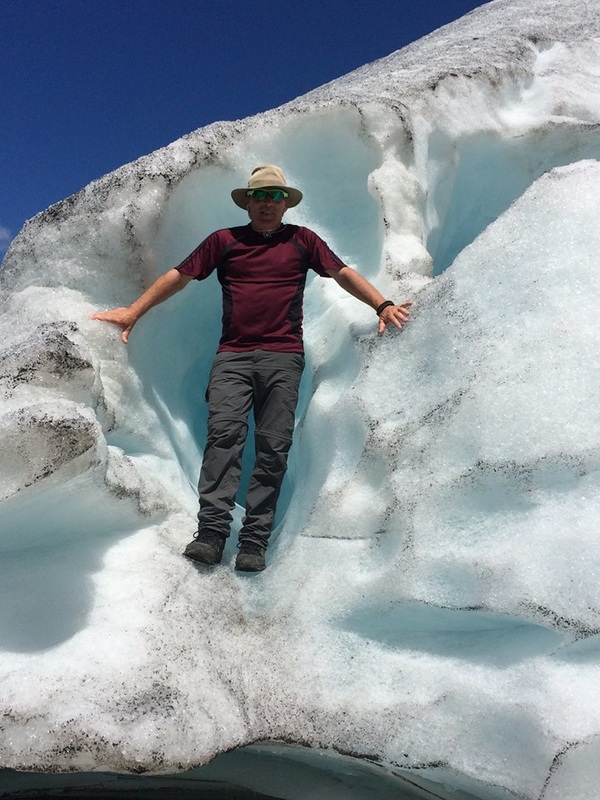
The next section of trail follows some step rocks, ladder like stairs, bridges and more steps. It's not long until you see Upper Lake and amazing ancient old boulders. Just before Upper Lake appears there's a carved bear you are suppose to acknowledge. History says you must greet the carved bear to receive good hiking weather. It's an easy path and soon you will come to some bigger rocks. Carefully walk to your left for a nice view point or lunch spot or go right and walk around the left to the campsite. There is a pit toilet here, several campsites and the Tzsil Glacier. You can climb up it carefully along the loose rocks. If you get high enough you can get a picture of all three lakes. See below for a better description on this added elevation. Climb up the rocks and you can see the Matier Glacier toward the Lower Lake direction.
Once you’re all rested up head back the way you came. The descent from Middle Lake to Lower Lake is steep in some areas so take your time and if you brought poles they will be helpful. Happy and safe trails.
A little foot note: Watch your speed outside of Pemberton. The speed limit is 30/Km's in some areas and it is monitored.
Trail Key: M~2~ST~R~RT~KF~DF~V
Length: 11 Km’s
Elevation: 400 meters
Pit Toilet: Yes-parking lot/Middle Lake & Upper Lake
Dogs: Yes
"A highlight of the park is the turquoise blue waters of Lower, Middle and Upper Joffre lakes, all three of which are located along the trail, and each more stunning than the last. Their striking, saturated blue colour is caused by “rockflour” – or glacial silt – that is suspended in the water and reflects green and blue wavelengths of sunlight. Joffre Lakes Provincial Park has opportunities for hiking, camping & mountaineering." BC Parks
I hadn't visited Joffre Lakes for a year because of the technical boulder field you had to climb across. I slipped every time and with scratches I thought I would never return until I read the boulder field was gone. I had to check it out for myself. Joffre Lakes is the very first hike to go from My Scaredy Cat Hikes to My Hikes. Thanks BC Parks!
Five minutes into the hike you are treated to Lower Lake, the first of three. It's green and blue colour with the glacier back drop is exciting to see. The bugs are fierce here so spray on. After you have taken many pictures head back to the trail branch and start your trek to Middle Lake.
It is a groomed path that climbs and climbs. Starting off in the quiet forest. Soon you pop into the open on a continued groomed trail. The beauty is stunning as you walk along continually gaining elevation. Along this trail there are boulders on either side of you and a rushing Joffre Creek on one side. At one point you can see the boulders laong the tree line of what you used to have to cross to see these stunning lakes. There are stairs at some parts of this trail. Keep going as you are not far from Middle Lake. Soon the green water pokes through the trees. There are bridges and cute little sitting areas. Keep going and Middle Lake greets you with a lakeside view and a rope swing if you dare splash into the mighty frigid glacier fed water. Keep walking along the trail as it skirts the lake. Soon you hear the thundering sounds of Joffre Creek which is now a powerful waterfall roaring down. Once you have seen this you'll think you have seen it all but you still have many more delights coming your way.
The next section of trail follows some step rocks, ladder like stairs, bridges and more steps. It's not long until you see Upper Lake and amazing ancient old boulders. Just before Upper Lake appears there's a carved bear you are suppose to acknowledge. History says you must greet the carved bear to receive good hiking weather. It's an easy path and soon you will come to some bigger rocks. Carefully walk to your left for a nice view point or lunch spot or go right and walk around the left to the campsite. There is a pit toilet here, several campsites and the Tzsil Glacier. You can climb up it carefully along the loose rocks. If you get high enough you can get a picture of all three lakes. See below for a better description on this added elevation. Climb up the rocks and you can see the Matier Glacier toward the Lower Lake direction.
Once you’re all rested up head back the way you came. The descent from Middle Lake to Lower Lake is steep in some areas so take your time and if you brought poles they will be helpful. Happy and safe trails.
A little foot note: Watch your speed outside of Pemberton. The speed limit is 30/Km's in some areas and it is monitored.
|
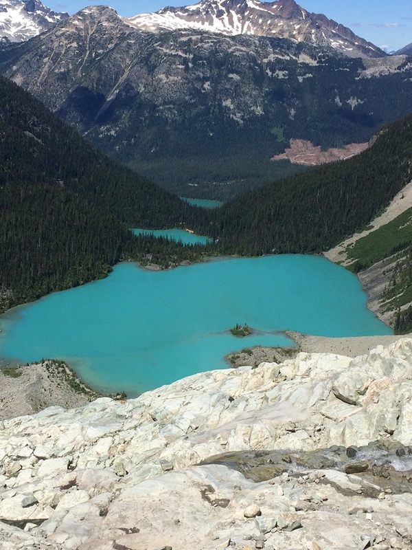
An added challenge...Once at Upper Lake follow the trail as it skirts the lake and goes to the campsite. Once there, there is a ridge like trail that goes up the rocks to the Matier Glacier. It is opposite the rushing waterfall and big rock. Follow that trail all the way to the top to the bottom of the ice field (in the summer months). Once there and 500 more meters of elevation gain brings you this view of all three lakes.
Photo credit: Randy Burge |