Upper Lookout: Hope Lookout Trail
Hope Lookout Trail: Hope, BC
Trail Key: M~2~V~ST~RT~R~KF~DF
Length: 4.6 K Rtn to lookout (can add more if you complete Joan Greenwood Loop Trail)
Elevation: 470 m (over 2.3 K)
Pit Toilet: No
Dog Friendly: yes with leash (steep sections/some exposed areas)
Directions: Traveling west on Old Hope-Princeton Way, take the first left under the overpass and park at the picnic tables. Follow the (gated) gravel road to the left and look for signs that mark the beginning of the trail. Courtesy of: Hope Mountain Centre
Follow the road past the sign post. Soon there's a trail sign. Keep going up the road as going right at the first sign takes you up a bike trail. The next TH is after the hill and to your right...follow the SP. In the beginning it's a somewhat steep, snaky trail.
Your first junction take a right and follow signs. Soon the trail goes down and flat. Don't get too comfy it doesn't last long.
Another junction go right and follow trail or you can add in the loop trail for some extra k's. After a short time you come to a chain assist. It's helpful as there are a few rocks to step up.
As you go along the trail steepenss with switch backs with a series of steps. The trail is very well maintained.
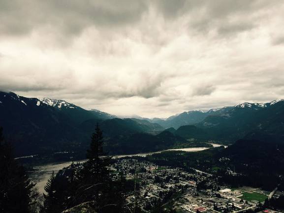
Soon you come to some mossy covered rocks as the trail meanders in and around them to yet another set of stairs. Finally the trail flattens as it skirts around the lookout. There's the Lower Lookout straight ahead but I suggest the final grunt up to Upper Lookout that has two benches over looking Hope, Fraser River & the highway bridge.It's about 200 metres. The trail goes past here but there's nothing to see. Once you have had your fill carefully head down the way you came. It's a steep descent so poles are a good idea. Happy & safe hiking!
Trail Key: M~2~V~ST~RT~R~KF~DF
Length: 4.6 K Rtn to lookout (can add more if you complete Joan Greenwood Loop Trail)
Elevation: 470 m (over 2.3 K)
Pit Toilet: No
Dog Friendly: yes with leash (steep sections/some exposed areas)
Directions: Traveling west on Old Hope-Princeton Way, take the first left under the overpass and park at the picnic tables. Follow the (gated) gravel road to the left and look for signs that mark the beginning of the trail. Courtesy of: Hope Mountain Centre
Follow the road past the sign post. Soon there's a trail sign. Keep going up the road as going right at the first sign takes you up a bike trail. The next TH is after the hill and to your right...follow the SP. In the beginning it's a somewhat steep, snaky trail.
Your first junction take a right and follow signs. Soon the trail goes down and flat. Don't get too comfy it doesn't last long.
Another junction go right and follow trail or you can add in the loop trail for some extra k's. After a short time you come to a chain assist. It's helpful as there are a few rocks to step up.
As you go along the trail steepenss with switch backs with a series of steps. The trail is very well maintained.
Soon you come to some mossy covered rocks as the trail meanders in and around them to yet another set of stairs. Finally the trail flattens as it skirts around the lookout. There's the Lower Lookout straight ahead but I suggest the final grunt up to Upper Lookout that has two benches over looking Hope, Fraser River & the highway bridge.It's about 200 metres. The trail goes past here but there's nothing to see. Once you have had your fill carefully head down the way you came. It's a steep descent so poles are a good idea. Happy & safe hiking!
|
|
|
|