Moderate, hills, steep, view, dog friendly, kid friendly Elevation: 575 meters Length: 3.8 km's return (can carry onto the peak fir additional land elevation Dogs: Yes Pit Toilet: no Hiking Checklist: Backpack, poles, MICROspikes (on icy/snowy days), 10-essentials, tell someone
Directions: Follow Harris road, Left on Hwy 11, Go north over the mission bridge: take first exit Right on route 7, Keep going straight to Hawkins Pickle Rd, Go straight along creek FSR.
Trail: Just past the FSR sign and leaning hydro pole with 15 on it is the trail-head start. There’s two trails; a very steep one and a gentle start but don’t get fooled it’s steep and hilly the entire way. I’ll explain the gentle start trail. The first T stay right as it goes down the nasty steep trail back to the road. Carry on up. It’s a steep climb on a windy trail. Listen for the chirping birds and the calm. There’s a few flat spots but not many. It just keeps going up. It’s always quite hilly. The next section is quite steep for sometime but there’s always a root, rock or tree to help you along.
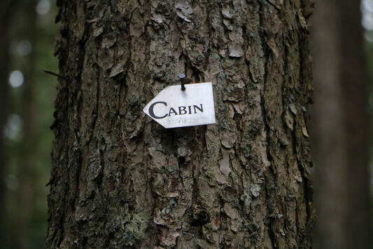
After climbing for a long time in this very steep section you’ll see a intersection from the north trail. We stayed left on the south trail (I don’t have too much info on the north trail). This last section is steep but a little shorter. It took us to a logging road. Cross the road and the trail carries on the other side the FSR. You’ll see a blue mark on the tree stumps, follow this path up. It’s still quite steep as you come to your second logging road. Follow the logging road straight up and on your left is a well worn unmarked trail. Follow it and soon you’ll see triangle metal markers. Not long after the metal marker you see what you wanted to see to all day, a metal marker with the words “cabin.” Follow that trail up to the cabin. It’s a lovely site as it comes into view. It was dedicated by the people of Dewdney for Ben von Hardenberg. A helicopter pilot who died on Aug 17, 2003 fighting a forest fire. He was 33 years old. Take pics, rest but don't forget to sign the book. Once you see the cabin, head up the trail to the second lookoutwhere there’s another view and a picnic table however both views are slightly over grown.
When you're ready head down the way you came. Crossing down the first logging road (there's a metal marker). The next logging road there's a reminder rock cairn (pile of rocks) as a trail marker. Carefully make your way down. It's steep and poles are essential to getting down safer and without very sore knees.
Happy & safe trails.
Note: You can start 1 k up the road to hike the north trail which intersects with the south trail. I have no info on this as we hiked the south trail up and down. Also you can go farther up to the peak but it’s just as steep and a total round trip of 9 k. Keep in mind it’s 30.3 % grade the entire way.