Hiking for The Scaredy Cat: Hikes in and around Vancouver, B.C. Canada
  • Trail Information
    • The Hiking Trails & Safety Information >
      • Abby Grind: Abbotsford
      • Alder Flats: Golden Ears
      • Alouette Mtn: Golden Ears Provincial Park
      • Ancient Cedars Trail
      • Al's Habrich Ridge Trail: Sea to Sky Gondola
      • B.C.M.C. Grouse Mountain
      • Bear Mtn: Mission, BC
      • Big Cedar & Kennedy Falls: Mount Fromme
      • Blue Mountain:Coquitlam
      • Bosumarne Falls: Chilliwack, BC
      • Bowen Lookout:Cypress Mountain
      • Bridal Falls Lookout: Chilliwack-Agassiz
      • Brother's Creek: North Vancouver
      • Community Forest: Chilliwack
      • Coquitlam Crunch: Coquitlam
      • Cheakamus Lake: Whistler
      • Crystal Falls: Coquitlam, BC
      • Dewdney Grind: Mission
      • Diez Vistas: Buntzen Lake
      • East-West Connector Bridge Trail~Golden Ears Provincial Park
      • Eaton Lake: Hope
      • Elfin Lakes: Squamish
      • Elk Mountain: Chilliwack
      • Evan's Creek: Golden Ears Provincial Park
      • First Peak: Seymour Mountain
      • Ford Mtn: Chilliwack
      • Grouse Grind: West Vancouver
      • Garibaldi Lake: Squamish
      • Harrison Grind/Campbell Lake: Fraser Valley
      • Harrison Lookout/Fire Tower
      • Heather Trail: Manning Park
      • High Note Trail: Whistler
      • Hillkeep: Chilliwack
      • Hope Lookout Trail
      • Horne Lake Caves Provincial Park: Vancouver Island
      • Jacobson's Lake to Palmer Pond
      • Joffre Lakes: Pemberton
      • Jug Island: Belcarra Regional Park
      • Ladner Creek Train Trestle: Coquihalla Hwy
      • Killarney Lake: Bowen Island
      • Lake Lovely-Squamish
      • Larch Meadows: Manning Park
      • Levette Lake Loop: Squamish
      • Lewx Qwo:m (luhw KWOM): Chilliwack
      • Lindeman & Greendrop Lakes: Chilliwack
      • Lightning Lakes: Manning Park
      • Lindsay Lake Loop: Buntzen Lake
      • Little Douglas Lake: Coquihalla Summit
      • Lower Falls-East Canyon Parking Lot: Golden Ears
      • Lynn Loop: Lynn Headwaters Regiona Park
      • Lower Hollyburn: Cypress Mtn
      • Lynn Peak: Lynn Headwaters Regional Park
      • McKee Peak-Cliffside Caves
      • Mehatl Falls
      • Menzies: Golden Ears Provincial Park
      • Minnekhada Park: Coquitlam
      • Mount Cheam: Chilliwack
      • Mount Fromme: North Van
      • Mount Sleese to Memorial Plaque: Chiliwack
      • Mount St. Benedict: Mission
      • Mount Strachan: Mount Seymour
      • Mt. Thom: Chilliwack
      • Mt. Gardner: Bowen Island
      • Mt. Woodslide
      • Munro & Denette Lakes: Coquitlam
      • Mystery Lake: Mount Seymour
      • Needle Peak/Flatiron: Coquihalla Highway
      • Norvan Falls: Lynn Headwaters Regional Park
      • Othello Tunnels-Nicola Valley Loop
      • Parkhurst Ghost Town: Whistler
      • Panorama Ridge: Squamish
      • Petgill Lake: Howe Sound
      • Poland Lake-EC Manning Park
      • Quarry Rock: Deep Cove
      • Ravens Bluff-Mission
      • Red Mountain: Mission
      • Salmon Ridge Trail: Chilliwack, BC
      • Sasquatch Caves: Hope
      • Sea to Summit: Sea to Sky Gondola
      • Skyline: Grouse Mountain
      • Skyline 1: Manning Park
      • Spirit Caves-Yale, BC
      • St. Mark's: Cypress Mountain
      • Statlu Lake
      • The Stawamus Chief: Squamish
      • Tikwalus Trail: Spuzzum
      • Trickle Creek Treehouse
      • Thacker Mountain Trail: Hope
      • Tunnel Bluffs: Howe Sound
      • Vedder: Chilliwack
      • Watersprite Lake: Squamish
      • Wedgemont Lake: Whislter
      • Wells Peak
      • Widgeon Falls
      • Williams Peak
      • Windy Joe: Manning Park
      • Woodland Walk to Sawblade Falls
      • Zoa Peak: Coquihallia Hwy
    • The Snowshoe Trails & Safety Info >
      • Artist Point
      • Bowen Lookout
      • Dog Mountain: Day
      • Callaghan Valley
      • Dog Mountain: Night
      • Eagle Bluffs
      • Elfin Lakes to Red Heather Hut >
        • Fat Dog
        • First Pump
        • Hollyburn
        • Lightning Lakes Loop
        • Rainbow Lake
        • Sasquatch Mountain Snowshoe: Hemlock Valley
        • SS Grind
        • Stawberry Flats
        • Zoa
    • The U.S.A. Hikes >
      • Blue Lake: Northern Cascades
      • Chain Lakes
      • Damfino Lakes
      • Deception Pass State Park: Washington, USA
      • Oyster Dome
      • Yellow Aster Butte
    • The Trail Walks >
      • Aldergrove Regional Park: Aldergrove
      • Blue Heron Reserve: Chilliwack
      • Brae Island: Fort Langley
      • Burn's Bog: Delta
      • Burnaby Lake Loop: Burnaby
      • Campbell Valley: Langley
      • Cathederal Grove: MacMillian Provincial Park:
      • Delta Watershed
      • East Sector Lands: Harrison Hot Springs
      • Elgin Park: Surrey, BC
      • Green Timbers: Surrey
      • High Knoll Park: Surrey
      • Houston Trail: Fort Langley
      • Katzie Marsh Loop: Pitt Meadows
      • Lower Falls: Golden Ears: Maple Ridge
      • Lower Seymour Conservation: North Vancouver
      • Lighthouse Park: West Vancouver
      • Mud Bay: Surrey
      • Redwood Park: Surrey
      • Reifel Bird Santuary: Delta
      • Rice Lake: North Vancouver
      • Richmond Nature Park: Richmond
      • Rolley Lake: Mission
      • Ruth Johnson Park: White Rock
      • Sasamat Lake: Port Moody
      • Spirea Trail: Golden Ears
      • Sunnyside Urban Forest: Surrey
      • Serpentine Bird Santuary
      • Shoesmith East Trail Loop: Maple Ridge
      • Spirit Trail: Ladner
      • Stanley Park Seawall: Vancouver
      • Sye'xw Cho'teqw Adventure Park
      • The Jetti: Iona Beach, Richmond
      • Tynehead
      • Yew Lake
  • My Blogging
  • Mt. Kilimanjaro
  • In the River Valley Hikes
  • West Coast Trail
  • Peru
  • Hiking Snapshots
    • Thru Hikes
    • Bears & Cougars +
    • Proper Hiking Footwear
    • Trail Etiquette
Picture

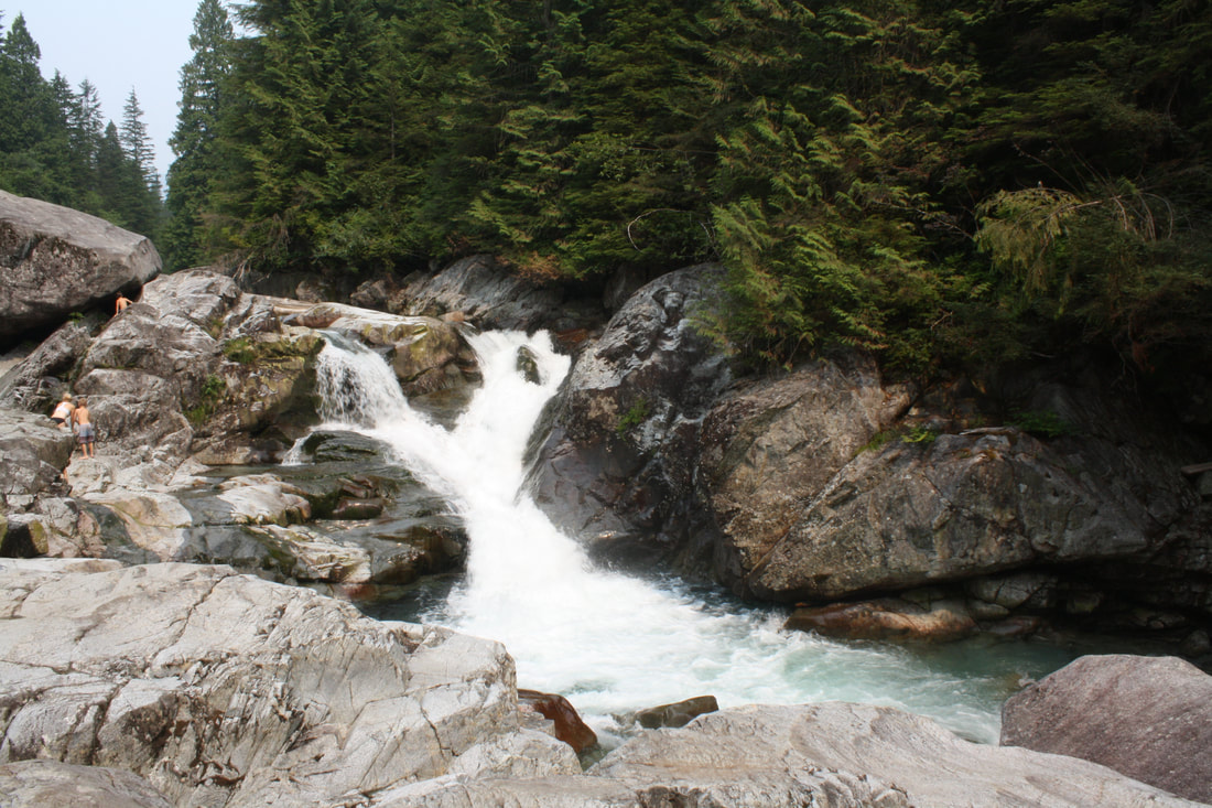
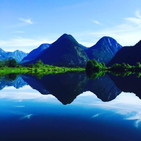
Widgeon Falls: Pitt Lake, BC

Hiking Key: M~2~R~H~CC~RH~DF~KF

Length: 2.9 K each way
Elevation: 50 m
Pit Toilet: yes at Canoe rental & TH start
Dog Friendly: yes-leashed

Directions: From Golden Ears Bridge. Left at 210 which turns into 132 then right at Neaves and follow road into parking lot.
Info: (2019) Rent canoes 7 days week. Open 8 a.m.-8 p.m. (stat holidays may be different). Canoes should be back at 6 pm. They'll call SAR if you're not back between 8-10 p.m. Call Pitt Lake Canoe rentals 604-836-7117. It’s $80 (2-man) day and $100 overnight. For a 4-man it’s $100/day or $150/night. It is first come/first serve. Cash only...& $50 damage deposit per boat. Be prepared to arrive early on a weekend or you will not get a canoe. You should have canoe experience and wear a pfd. PFD & paddles included with fees. I recommend dry sacks to put your stuff in and water shoes in the canoe. We clipped our packs & hiking shoes on the canoe in case it tipped over. It's about 45 mins each way in the canoe and depending on your fitness level an hour to the falls.
​

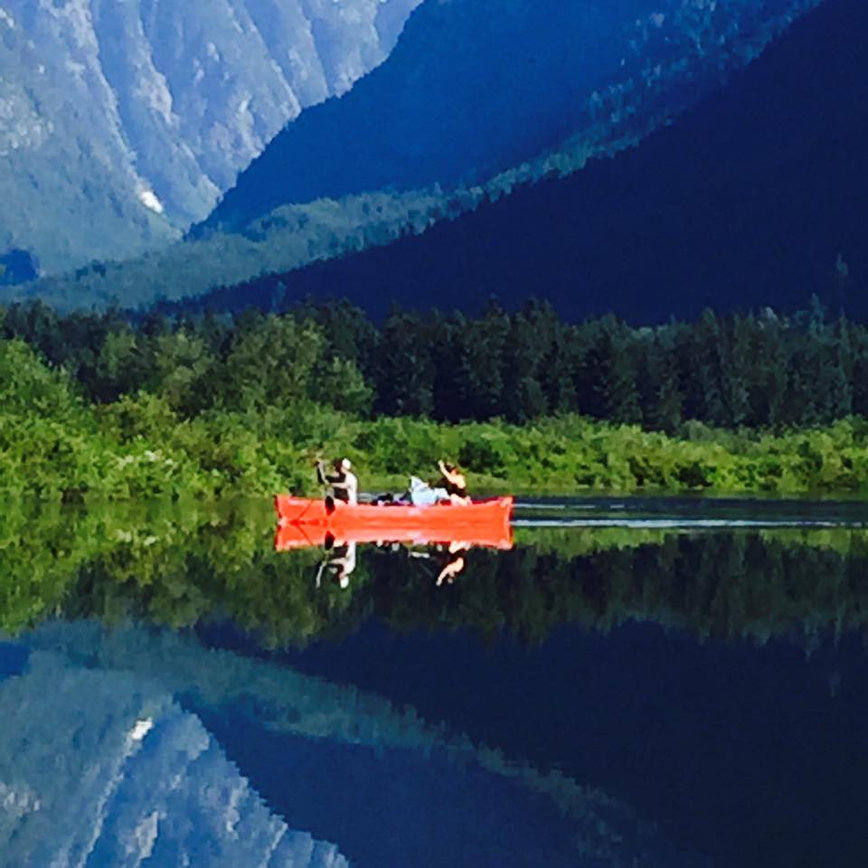
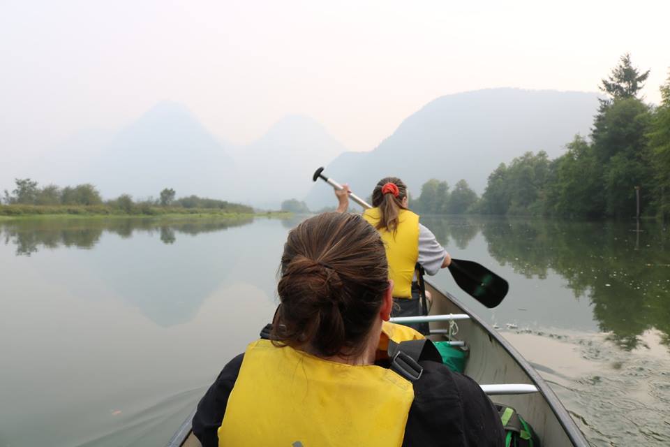
Canoe: Cross Pitt lake and toward marsh. Be careful as speed boats race along Pitt River. Once in the slough, follow along like a "s". There's no left or rights at this point so keep going along. After about 30 mins of paddling you come to a curvy "y" junction with a sign post 'Widgeon Camp" stay left. The slough continues snaking its way along. It's peaceful. Minnows jump at the surface as you paddle along. You come to another curvy "y" stay left. Soon after you'll see the beach. Park your boat here. Pull it up high as this is a tidal lake (remember your canoe number). Be prepared to get out of the canoe at some parts if the water is low...

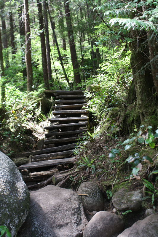
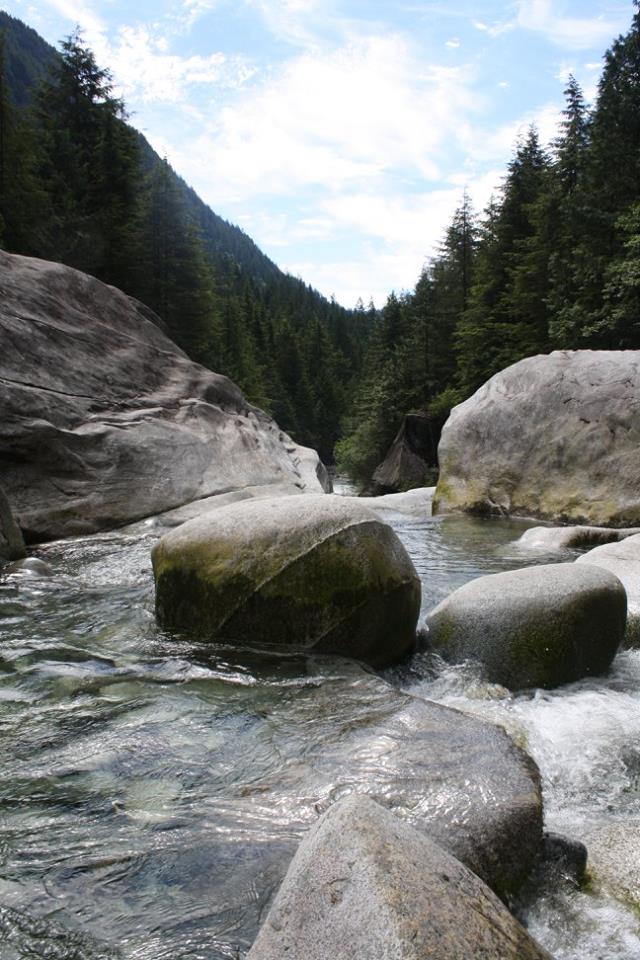
Your hike begins to the right of the pit toilets. It starts off on a gravel path. Follow this along. The trail is mostly flat but dips down into an old dry creek bed. A few moments later there's a junction. Stay left to carry on the road or right to walk through the forested giants. Oh the stories they could tell. We went through the forest for the last 1.5 kms to the falls. Follow the trail as it heads to a creek lookout. The trail descends down like a switchback as you come to your first boardwalk. Not long after another tired boardwalk. The trail winds around to another board walk. A muddy creek crossing and another tired boardwalk. Soon after a wide log bridge. Soon after you climb up a series of stairs. The trail climbs here over roots and rocks. The trail flattens and comes to short tired board walk and then climbs again for a few moments. Then a newer boardwalk. After a few downs you come to a log step up and a new boardwalk with a railing. Shortly after, another new board walk. Not long after another new boardwalk as the creek rushes far below. A short climb with many roots and trees to help you along. After a the steepest climb yet you come to your last sign post. It's 50 m to the falls. Go right... This is a steep climb down. Once at the bottom another two new boardwalks then two new boardwalks sandwiched between a tired one. Then another old board walk and several old stairs and two more old boardwalks. Make your final descent down the stairs and hop across a few rocks. You are at Widgeon Falls. There are many volcanic rocks to explore and depending on the water levels swimming holes to cool off in or soak your feet. Once you're ready to head back go back the way you came. You can go through the giants or walk along the road. In the beginning the road is a little steep going down with loose pebbles and over grown bushes. Before you knwo it you are back at the junction and you have to carry on the old logging road. Once back at your canoe head back trough the slough and return your canoe at the rental shop. This is one of my all time faves...Happy & safe trails.


Proudly powered by Weebly
  • Trail Information
    • The Hiking Trails & Safety Information >
      • Abby Grind: Abbotsford
      • Alder Flats: Golden Ears
      • Alouette Mtn: Golden Ears Provincial Park
      • Ancient Cedars Trail
      • Al's Habrich Ridge Trail: Sea to Sky Gondola
      • B.C.M.C. Grouse Mountain
      • Bear Mtn: Mission, BC
      • Big Cedar & Kennedy Falls: Mount Fromme
      • Blue Mountain:Coquitlam
      • Bosumarne Falls: Chilliwack, BC
      • Bowen Lookout:Cypress Mountain
      • Bridal Falls Lookout: Chilliwack-Agassiz
      • Brother's Creek: North Vancouver
      • Community Forest: Chilliwack
      • Coquitlam Crunch: Coquitlam
      • Cheakamus Lake: Whistler
      • Crystal Falls: Coquitlam, BC
      • Dewdney Grind: Mission
      • Diez Vistas: Buntzen Lake
      • East-West Connector Bridge Trail~Golden Ears Provincial Park
      • Eaton Lake: Hope
      • Elfin Lakes: Squamish
      • Elk Mountain: Chilliwack
      • Evan's Creek: Golden Ears Provincial Park
      • First Peak: Seymour Mountain
      • Ford Mtn: Chilliwack
      • Grouse Grind: West Vancouver
      • Garibaldi Lake: Squamish
      • Harrison Grind/Campbell Lake: Fraser Valley
      • Harrison Lookout/Fire Tower
      • Heather Trail: Manning Park
      • High Note Trail: Whistler
      • Hillkeep: Chilliwack
      • Hope Lookout Trail
      • Horne Lake Caves Provincial Park: Vancouver Island
      • Jacobson's Lake to Palmer Pond
      • Joffre Lakes: Pemberton
      • Jug Island: Belcarra Regional Park
      • Ladner Creek Train Trestle: Coquihalla Hwy
      • Killarney Lake: Bowen Island
      • Lake Lovely-Squamish
      • Larch Meadows: Manning Park
      • Levette Lake Loop: Squamish
      • Lewx Qwo:m (luhw KWOM): Chilliwack
      • Lindeman & Greendrop Lakes: Chilliwack
      • Lightning Lakes: Manning Park
      • Lindsay Lake Loop: Buntzen Lake
      • Little Douglas Lake: Coquihalla Summit
      • Lower Falls-East Canyon Parking Lot: Golden Ears
      • Lynn Loop: Lynn Headwaters Regiona Park
      • Lower Hollyburn: Cypress Mtn
      • Lynn Peak: Lynn Headwaters Regional Park
      • McKee Peak-Cliffside Caves
      • Mehatl Falls
      • Menzies: Golden Ears Provincial Park
      • Minnekhada Park: Coquitlam
      • Mount Cheam: Chilliwack
      • Mount Fromme: North Van
      • Mount Sleese to Memorial Plaque: Chiliwack
      • Mount St. Benedict: Mission
      • Mount Strachan: Mount Seymour
      • Mt. Thom: Chilliwack
      • Mt. Gardner: Bowen Island
      • Mt. Woodslide
      • Munro & Denette Lakes: Coquitlam
      • Mystery Lake: Mount Seymour
      • Needle Peak/Flatiron: Coquihalla Highway
      • Norvan Falls: Lynn Headwaters Regional Park
      • Othello Tunnels-Nicola Valley Loop
      • Parkhurst Ghost Town: Whistler
      • Panorama Ridge: Squamish
      • Petgill Lake: Howe Sound
      • Poland Lake-EC Manning Park
      • Quarry Rock: Deep Cove
      • Ravens Bluff-Mission
      • Red Mountain: Mission
      • Salmon Ridge Trail: Chilliwack, BC
      • Sasquatch Caves: Hope
      • Sea to Summit: Sea to Sky Gondola
      • Skyline: Grouse Mountain
      • Skyline 1: Manning Park
      • Spirit Caves-Yale, BC
      • St. Mark's: Cypress Mountain
      • Statlu Lake
      • The Stawamus Chief: Squamish
      • Tikwalus Trail: Spuzzum
      • Trickle Creek Treehouse
      • Thacker Mountain Trail: Hope
      • Tunnel Bluffs: Howe Sound
      • Vedder: Chilliwack
      • Watersprite Lake: Squamish
      • Wedgemont Lake: Whislter
      • Wells Peak
      • Widgeon Falls
      • Williams Peak
      • Windy Joe: Manning Park
      • Woodland Walk to Sawblade Falls
      • Zoa Peak: Coquihallia Hwy
    • The Snowshoe Trails & Safety Info >
      • Artist Point
      • Bowen Lookout
      • Dog Mountain: Day
      • Callaghan Valley
      • Dog Mountain: Night
      • Eagle Bluffs
      • Elfin Lakes to Red Heather Hut >
        • Fat Dog
        • First Pump
        • Hollyburn
        • Lightning Lakes Loop
        • Rainbow Lake
        • Sasquatch Mountain Snowshoe: Hemlock Valley
        • SS Grind
        • Stawberry Flats
        • Zoa
    • The U.S.A. Hikes >
      • Blue Lake: Northern Cascades
      • Chain Lakes
      • Damfino Lakes
      • Deception Pass State Park: Washington, USA
      • Oyster Dome
      • Yellow Aster Butte
    • The Trail Walks >
      • Aldergrove Regional Park: Aldergrove
      • Blue Heron Reserve: Chilliwack
      • Brae Island: Fort Langley
      • Burn's Bog: Delta
      • Burnaby Lake Loop: Burnaby
      • Campbell Valley: Langley
      • Cathederal Grove: MacMillian Provincial Park:
      • Delta Watershed
      • East Sector Lands: Harrison Hot Springs
      • Elgin Park: Surrey, BC
      • Green Timbers: Surrey
      • High Knoll Park: Surrey
      • Houston Trail: Fort Langley
      • Katzie Marsh Loop: Pitt Meadows
      • Lower Falls: Golden Ears: Maple Ridge
      • Lower Seymour Conservation: North Vancouver
      • Lighthouse Park: West Vancouver
      • Mud Bay: Surrey
      • Redwood Park: Surrey
      • Reifel Bird Santuary: Delta
      • Rice Lake: North Vancouver
      • Richmond Nature Park: Richmond
      • Rolley Lake: Mission
      • Ruth Johnson Park: White Rock
      • Sasamat Lake: Port Moody
      • Spirea Trail: Golden Ears
      • Sunnyside Urban Forest: Surrey
      • Serpentine Bird Santuary
      • Shoesmith East Trail Loop: Maple Ridge
      • Spirit Trail: Ladner
      • Stanley Park Seawall: Vancouver
      • Sye'xw Cho'teqw Adventure Park
      • The Jetti: Iona Beach, Richmond
      • Tynehead
      • Yew Lake
  • My Blogging
  • Mt. Kilimanjaro
  • In the River Valley Hikes
  • West Coast Trail
  • Peru
  • Hiking Snapshots
    • Thru Hikes
    • Bears & Cougars +
    • Proper Hiking Footwear
    • Trail Etiquette